Qikiqtarjuaq, Nunavut, Canada (66N)

The green line running north to south on this map represents Auyuittuq National Park boundaries. Inside the park to the left of the green line, you can see 3 fiords, Maktak, Coronation and North Pangnirtung. Below the North Pang Fiord is a river, which empties into a small bay, that is located on the right of the green boundary line. As you follow this river out to the Canso channel, it is narrowed by a waterfall. To the left of that waterfall is a tiny beach / inlet directly looking out onto Canso channel. This tiny inlet/beach left of the waterfall, below the North Pang Fiord, is where our camp was located. This is also the same magical place which I can't seem to stop talking about.

This is what the view and our camp looked like. To the left of camp, just around the corner is the North Pang Fiord. Directly in front is the Canso channel. Behind our camp was a small puddle of mixed salt and fresh water. At high tide, the salt water would flow into this pond. However, from the high mountains trickled down a fresh water stream - so the camp was equipped with running fresh water.
While the little river had the most use, the pond did help create magical views and reflections for photos.
I was part of the crew and visitors for a total of 2 weeks in the middle of August, 2017. This is considered the best part of summer in the North, when all the ice has melted and the fishing and boating season is in full gear. However, above the Arctic Circle, there is plenty of ice still around which calve off from the main glacier near by, the Penny Ice Cap. This glacier lies in the heart of Auyuittuq park, but the fiords allow for a closer viewing of the glaciers, maybe even spot some calving ice.
This trip had 2 main focus: viewing polar bears and all other arctic animals and witnessing the magic of glacial ice. Boy, we were all in for the most amazing treats over the next 2 weeks.
Week 1 had much more sun, which provided heat during the long days we spent on the boats and hiking/ kayaking at our lunch spots. Sun helps to take magical pictures with very little effort.
First stop from Iqaluit, refuel and unload in Pangnirtung.
Flying over the Penny Ice Cap from Pang to Qikiqtarjuaq. Clear visibility, and our pilot stayed very close to the tops of every mountain. Great start, to say the least.
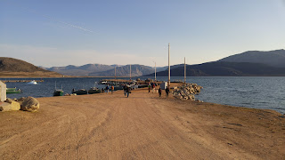
Arriving to Qikiqtarjuaq. Once we made it to the parks office, we watched a safety video on camping and hiking in the park. Very retro video but very helpful in safety tips.
Once the boats were loaded with bags and people, we were ready to find camp! South of Qikiqtarjuaq, 1 hour by boat, is where our little private beach awaited to be occupied.
This was my workstation for the next 14 days - washing dishes for 3 meals per day - and 2 very fancy chefs with unlimited imaginations - therefore all pots and pans were used in the process of serving luxurious cousine daily - and I did not mind at all since I too got to enjoy the fancy feasts :)
Our camp from many angles - as if it was a dream
Boat ride up the Coronation Fiord - magical views and reflections. The boat is a great reference point to show the size of the mountains.
The first veiw of Penny Ice Cap as it flows into the Corocation Fiord. We did not witness calving but it did not matter because the view of the glacier silenced all on the boats. Lights, camera, action!
We took a day off and visited the waterfall - this is also the time I spotted my first polar bear, as he was making his way to our camp. Stressful to say the least. But all turned out well!
Week 2 had less sun available to us, but the clouds provided an aerie and majestic landscape, also great for photography. Visiting this 7 year old glacier ice hanging out in the middle of the ocean - collecting fresh water from a waterfall we noticed.
A few of the tourists took advantage to go kayak among the glacial ice even though we had snow fall on this day. It was too chilly for me to join, but enjoyed the hikes either way.
Cape Shire, also known as a bird sanctuary, is where we spotted polar bear tracks - only to find him walking on the other side of this mountain range. Very exciting location and totally worth the visit.
Qikiqtarjuaq beach with broken ice.
Qikiqtarjuaq from a distance - on a hill near the famous rock pile and from the plan which took all of us home - me, back to Iqaluit.
Pangnirtung stop over - but this time I got a nice aerial view
Iqaluit, my home from the air.
Photos by others on this expedition:
Rosi's photos:


No comments:
Post a Comment